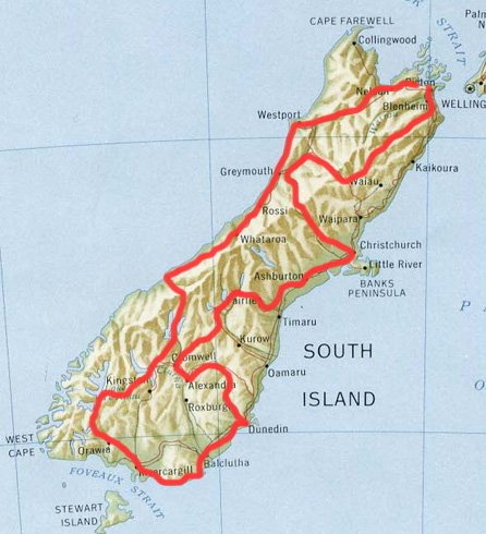
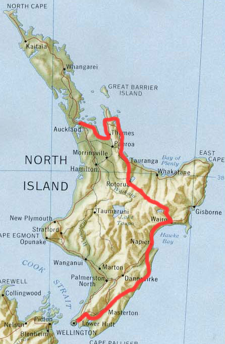
New Zealand
|
 |
|||
North Island
|
|
|||
South Island
|
 |
|||
|
||||


7th - 12th January 2006 - Auckland Luckily an old work colleague of ours, Simon, had a project underway in Auckland so we managed to scrounge a room with him. It turned out that he had a fantastic pad overlooking the harbour and right next to the viaduct bars and restaurants. He provided a great tour of all the happening places - he seemed to know someone in every other restaurant! After refuelling, restocking supplies, replacing broken bits, sourcing maps and quizzing the locals about the places to go we set off for our tour of kiwi land.
|
Azur blue of the Auckland harbour, when we landed the pilot claimed reasonable visibility at 50km's - we were lucky to get 50 metres in parts of China |
|||
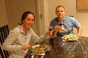
Isa chilling out in style with Simon after one day in Auckland. |
After only two days in Auckland, Terry was already scaring the locals! |
|||
If there is a tongue pointing out, it is Maori art. |
All made on our camping stove, promise! |
|||
12th January 2006 - Auckland to Kawakawa bay - 61 km We left Auckland under glorious sunshine and cycled passed some fine beaches - and it was only the beginning. It took us some time to leave the sprawling suburbs of Auckland behind (25 km following the coast) but finally we reached the rolling green hills which reminded us so much of England. Fenced fields, greenery, sheep: they were all there. But every parcel of the land left to itself was covered in the most luxurious rainforest. They call it bush here and it is packed with giant fern trees, pine trees and many other plants we cannot identify. No wild camping option here. As for the nice green fields, it turned out to be a problem too because everything is fenced and locked off. We persisted and finally found an old field with a broken gate right in view of the road. The least secret wild camping of our trip so far. |
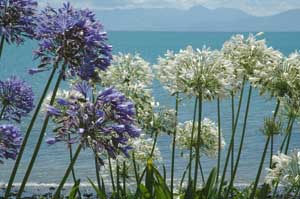
The Firth of Thames with the popular "big flowers" that have been planted in peoples gardens and seem to readily escape into the surrounding countryside - the Agapanthus soon to be banned as a "BioSecurity Risk" |
|||
The mountains of the Coromandel peninsula, looking across the bird infested waters of the Firth of Thames, a bird watchers paradise. |
13th January 2006 - Kawakawa bay to Thames - 83 km After more rolly green hills, we followed the coastal road to Thames. The beaches are awesome and they are actually growing because of the huge amount of shells being deposited. The cheniers thus formed fill up thanks to the Mangrove, which has become Terry's favourite tree since our visit to Miranda bird watching centre (see our flora and fauna report). We spent the night in Thames, which is the biggest town we have seen since leaving Auckland. 10,000 inhabitants, but where are they all? It is such a quiet little town. Maybe they are down in some mines, still looking for gold, which abounded in the area last century. |
|||
Our first encounter with the rainforest on the edges of Auckland suburbs, massive tree ferns and loads of stuff we have no names for |
|
|
||
Rolling hills, blue skies and locked gates. On the route from Auckland to Rotarua it was very difficult to find places to wild camp, there are no footpaths, the fields are all completely fenced and the gates are locked
|
Shells everywhere on the beach near Miranda
A nice picnic spot overlooking the Coromandel peninsula |
|||
14th January 2006 - Thames to Coromandel - 62 km We took a quick tour of the Thames Saturday market and managed to weigh ourselves down a little more. Isa invested in a sarong to cover her worn out cycling shorts and a selection of spices mean that our camp cooking should take on a little more variety. The road from Thames to Coromandel town hugged the coast for 40 kms providing us with wonderful views of the Firth of Thames and the rugged mountains of the Coromandel peninsula. The road then dived viscously inland as we began to experience our first proper hills. Unlike China the road gradients are not there to accommodate overloaded trucks by climbing gradually - the hills here go straight up - typically ranging from 8% to 16% in gradient. This makes for hard and painful uphills. We were rewarded with great views of distant islands, mountains and beaches before screeching back down hill. We camped that evening just North of Coromandel town - with 4 other cycle tourists - HansPeter and Ursula from Switzerland (we had previously met in Auckland) and Axel and Brigit on their honeymoon from Germany.
|
Brigit and Axel, 2 german cyclotourists we met on the route. They chose a 3 month tour of New Zealand as their perfect Honeymoon trip - congratulations! |
|||
After the complication of the Chinese characters it was nice to come across some simple, clear and concise signposting in a language we understand
|
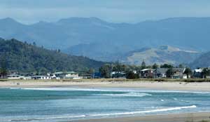
15th January 2006 - Coromandel Town to Whitianga - 50 km Poor legs!!! The day started with a nasty 400m, 12% climb, which put off some of our fellow cyclotourists. We thought we were up for it, but we did not expect the next three steep hills. One of them was 18% steep for a section of 100m. Nothing else to do but curse and slowly push on. But the beaches on the Pacific side of the Coromandel peninsula were well worth it. White sand, superb blue sea. We added a note of colour with our bright red noses despite three applications of our factor 35 suntan cream. We stopped for the evening in Whitianga, which has a fabulous beach. Plenty has happened here: it is said that it is in this bay that the first Polynesian explorer, Kupe, has landed. The bay is also called Mercury bay because captain Cook stopped here to do some astronomical observations (of the planet Mercury as it happened). |
|||
The wonderful views across the Northern section of the Coromandel peninsula
|
The imposing Castle Rock on the northern Coromandel peninsula
|
|||
16th January 2006 - Trying to rest in Whitianga Since there was no high structure (cathedral, tower or other) to be climbed, Terry decided to spend our day of rest doing a bit of sea-kayaking. It was without counting on the fierce wind that started to blow from the coast on our way back. We made it back to Whitianga beach after much struggling. For once it was not our legs that were hurting!
17th January 2006 - Whitianga to Hahei beach - 20 km The Coromandel peninsula is far too beautiful and the Kiwis far too friendly. After a few chats with the locals in Whitianga and having gathered a long list of places to visit in the area, we stopped shortly after in Hahei. The day was so beautiful that we decided to stroll to Cathedral Cove (a big carved out arch in the cliff) and to do a bit of snorkeling in the marine nature reserve. Things did not quite go to plan though. Isa lost her ring in between some rocks and after an unsuccessful hour trying to find it, we did not have enough time to walk to Cathedral Cove. As for the snorkelling, the water turned out to be too murky to see further than one meter ahead!
|
A sweeping descent on the Coromandel peninsula, the road either goes up or down - there is no in between |
|||
The Coromandel peninsula is littered with gorgeous beaches and coves - it makes it very difficult to keep on cycling.
|
New Zealand has been really quiet and easy compared to China. Here is an example of the type of things that happens to us now. In the morning, Isa was waiting for Terry on a car park space. She was too lazy to make it onto the pavement and was cleaning her sunglasses. She heard a light bipping, turned around and saw a woman waiting to park her car. So Isa moved to the pavement and carried on cleaning her sunglasses, thinking no more of it. The woman came right up to her and... apologised... for not having bipped. "It was the car behind me, I am sorry, really, I would not have bipped at you". Hey??? This is a bit far too civilised for us after more than two months spent cycling in the midst of the vicious Chinese lorry drivers. 18th January 2006 - Hahei beach to Whangamata - 75 km Up and down, up and down, and again would summarise the day nicely. The views were not so outstanding because we mainly crossed a logging area. We only saw the Pacific again when we arrived in Whangamata, famous for its surfing beach, but we did not get a chance to try it. We left the busy camping sites behind (it is the holiday season here) and headed for a quiet site in the bush. |
|||
The Norfolk pines look like they should be smaller, they are like photoshop trees - just stretched from normal to gigantic size
|
Quiet roads and green valleys, but a little too hot for sweaty Terry
|
|||
Isa surfs in with style, poise and grace on the sea kayak (our rest day from cycling), 5 out of 5
|
Terry should just count himself lucky that he didn't lose his hat or glasses, 1 out of 5
|
|||
Whitianga and Buffalo beach |
19th January 2006 - Whangamata to Katikati - 73 km Another big uphill to warm up our legs straight from the beginning. But the rain caught up with us in Waihi. We just had time to reach a coffee in time to escape being properly drenched. We managed to spend 2 hours and a half munching sandwiches and drinking huge coffee bowls before running out of things to do, eat and talk about. Luckily the rain stopped shortly after we were back on the bikes.
|
|||
We cycled along Wahei beach (not much view as it is lined with houses) before going back onto the SH2 (State Highway 2). From then on it was quite an unpleasant ride: the road is wide and busy with lorries going to Tauranga, the biggest export port of New Zealand. We however found a lovely wild camping spot by the beach in Katikati. On top of a fabulous sunset and fabulous sunrise over Tauranga harbour, we had toilets with toilet paper and soap! |
At last a single lane road. On the way to Cathedral cove and Hahei Beach
|
|||
Stingray bay, where we decided to try our hand at a bit of snorkelling
|
Stingray bay. Under doctors orders to ensure full recovery of the frozen toes, Isa was forced kicking and screaming to the beach
|
|||
 |
(Left) Over the last 5 years New Zealand has become synonymous with Middle Earth, hobbits and the return of The Ring to mount doom. We were determined not to jump onto the popularist Lord of the Rings bandwagon - but just like the book fate can have the strangest twists. Isa was carefully applying her factor 35 anti-Orc cream when her silver and diamond ring (bought by Terry and forged in the furnaces of Hereford) popped off her finger and bounced down into the crevices of the surrounding boulders. Despite an hour lifting rocks and boulders, with sticks, by hand and rummaging amongst the crabs, crayfish and shellfish the ring had mysteriously vanished. The tide was coming in and we had still not tried our snorkelling - it was no loss as the waves in the maritime reserve had reduced the visibility to less than a metre. We packed our bags with a last look for the ring - with no joy - but as we walked away the incoming tide gurgled on the underside of the rocks something that sounded eerily like " My precious". |
|||
It seemed to be along time coming but 12,000 kms from Worcester appeared in the Wentworth Valley |
The far North of the Coromandel peninsula, with Islands poking out to the Pacific Ocean |
|||
The Pinnacles, a beautiful clear river and the very common bright orange flax flowers
|
|
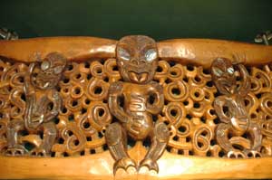
Maori wood carving from the meeting house in Rotarua
|
||
Sunrise over the Tauranga natural harbour |
20th January 2006 - Katikati to Rotorua - 101 km We carried on along the far too busy SH2 before turning South on a quieter road towards Rotorua. Unfortunately, the road was not as quiet as it was supposed to be. It has been recently widened and cut through the hill with cruel steep ascents and descents. We did not enjoy it at all and we were happy to reach Rotorua in the evening. And it was no surprise we were tired (Isa was anyway): we did more than 100km and climbed 1316m. This is insane!!! And the highest point of the day was only 486m. Everything is up and down in New Zealand.
|
|||
(above and below) The Kuira park in central Rotarua, a fascinating, steaming, stinking, bubbling selection of the earth opening its bowels.
|
The Kiwi's have all been very friendly so far - but we wouldn't like to get into their bad books
|
|||
|
21st - 22nd January 2006 - Malodour in Rotorua We spent a couple of days recovering in Rotorua. And what best to poke your noses over some stinking bubbling holes smelling of rotten eggs. There are some really strange things happening under the earth crust around here. We soothed our nose in the impressive ice cream parlour of Lady Janes (thanks for the recommendation Camilla!) |
|||
Maori wood carving for the entrance gate to a cemetary
|
The SH2 from Waihi to Tauranga - too busy, too fast, too wide, too much up and down. Tauranga is New Zealand's busiest export port - so too many trucks. Many cyclist get the bus for this 40km stretch
|
|||
23rd January 2006 - Rotorua to Green Lake - 52 km We headed off in the direction of the pretty lake district South-East of Rotorua. There are no less than four lakes there and stuck in between, a buried village under a few meters of mud. The nearby Mount Tarawera decided to erupt in 1896, burying the whole village under mud. It also destroyed some silica terraces that Victorian tourists used as hot pools. These pink and white terraces were named at the time the 8th wonder of the world. |
The tongue gives it away as Maori art, recovered from the buried village
|
|||
One of the buried village's houses. The nearby volcano erupted into the base of a lake and spewed mud and rocks over the surrounding area to a depth of 1.5 metres
|
New Zealand is a country full of greenery and waterfalls - we were to find out where all that water comes from in the next few days
|
|||
The Mount Tarawere volcano - it last went off in the 1896 killing locals, Victorian Tourists and burying the local villages
|
24th January 2006 -Green Lake to Murrapara - 51 km We started the day by visiting Waita-O-Tapu site where there is a concentration of fuming holes, but this time with weird and wonderful colours. There is also a geyser there that starts everyday at 10.15 for the pleasure of about 200 tourists all sat in a small outdoor theater designed for the purpose. A chap came along and dropped some detergent powder in the geyser hole to start it. After two minutes, there is a jet of water about 20m high. But is this really a geyser then? When we left Waita-O-Tapu, the weather has decided to turn for the worse. We had strong rain and strong wind against us. We stopped 15 km short of Murrapara, our target for the day, and were getting ready for a very wet and windy nights camping. A chap in a truck came along and said he could take us to Murrapara. Needless to say, we were more than happy to accept a lift. This was quite a hairy 15 km. Dave drove very fast, which would have been okay, but with us two in the car, the windows steamed right up and we could not see anything at all. In Murrapara, we drove around the deserted campsite and Dave decided to put us up for the night. After being treated to a delicious meal of Venison hunted in the forest, we watched a psychic show on TV. Two psychic were given the police clues about a 35 years old murder, which happened pretty much in the lay by by where we camped the night before. Scary! |
|||
At last Terry met someone who finds it more difficult to get a cycling helmet that fits
|
Lichens and mosses on the trees surrounding the hot bubbling mud pools
|
|||
The champagne pool, 74 degrees C, with different elements precipitating at different temperatures to produce a fantastic selection of colours
|
Snickers used to be Marathon and Starburst used to be Opal Fruits. This sulphurous lake was exactly the same colour as the lime flavoured Opal Fruit
|
|||
It was also great to have a chance to talk to Dave and his wife about the area problems. Since the closure of most of the local logging industry, the booming little town of Murrapara is slowly dying. Out of 5000 inhabitants, only 1500 remain and out of 30 shops, only four are still there and struggling with burglaries. Dave seemed to think that most of the problems are down to the younger Maoris, who are not interested in doing any work. But as he put it himself: "there is only two things I hate in life: racism and black people!". Big mouthed but despite the appearances, a heart in the right place.
|
Unsealed road for the next 90 kms - perfect for cycling - less cars and usually much slower
|
|||
Rivers and forest with a rare glimpse of grass in the wild Te Urewera National Park |
Camping in the hut at Taupeupe Saddle - most of the graffiti was unreadable to us as it was in Maori
Waterfalls, rain and gravel roads on the descent to Lake Waikaremoana
|
|||
Lake Waikaremoana and the roller coaster road that dips and swerves around the lake
|
25th January 2006 - Murrapara to Taupeupe Saddle - 66 km Mostly off road for another rollercoster of a drive on gravel roads. But the lack of cars and the fantastic native rainforest (or bush) made up for the effort. Another record was beaten that day: 1469 meters were climbed to the greatest joy of Terry! The bush was fantastic. As soon as we entered Te Urewera national park, the forest was everywhere, on every slope. No room for grass here. Giant ferns, all types of podocarps (trees that grow in only a few parts of the Southern Hemisphere) and beeches are thriving. Most of the trees are new to us and named in Maori, so we really struggle to remember what they are. Strong rain started falling towards the end of the afternoon and we stopped under a concrete shelter on top of the last pass for a very wet night amongst the graffiti and spiders. |
|||
The impressive, rain engorged Mokau falls on the shores of Lake Waikaremoana, Isa is just visible cycling over the bridge
|
The State Highway 38 through Te Urewera National park - if only all state highways were this quiet. Terry was delighted to be deep inside the native New Zealand bush. |
|||
26th January 2006 - Taupeupe Saddle to Lake Waikaremoana- 101 km It was then all downhill to the jewel of the park, lake Waikaremoana. Unfortunately, the rain had not stopped all night and seemed to be set for the day. We reached the lake absolutely soaked and sought refuge in a little cabin by the lake. All our gear needed drying. The combined rain and wind were so bad that some of our holey Ortlieb bags had started leaking!
27th January 2006 - Lake Waikaremoana We decided that one day in the dry would not be too much of a luxury before heading off on some more gravel roads. We took the day off to visit another lake nearby, lake Waikareiti. The walk through the bush was awesome and the water of the lake absolutely pristine. There are a few islands which are totally rat, stoat and possom free in the middle of the lake and so are a haven for many of New Zealand threatened bird species. The possom was introduced from Australia to New Zealand for the fur trade. Since then they have escaped and it is estimated that there are now 70 million roaming over New Zealand. They eat the native bush and win the competition for food over the endemic birdlife such as the Kiwi. The DOC are actively encouraging their destruction with possom traps; possum fur sells for $75 a kilo. Amazingly in Australia the possum is threatened and protected species.
|
The intrepid explorers deep in the unexplored rain forest on the easy 1 hour family track up to Lake Waikareiti
|
|||
The rain cleared away for a trip down towards Napier. The view across Lake Waikaremoana and Panekiri Bluff
|
28th January 2006 - Lake Waikaremoana to Waihua - 90km Back on the bike, but this time in the sun and with some lollies offered by the campsite lady to get us over the big hill. She must have meant "hills" because even though the day was mostly downhill, we climbed a lot. New Zealanders do not know the meaning of flat. When they say "undulating", they mean "a long series of steep short hills will kill your legs and crush your spirit". Anyway, we could finally see the lake Waikaremoana in all its splendour. As soon as we reached the border of the national park, the native bush disappeared in quite a dramatic fashion, leaving room for sheep and fields or planted forests, which look utterly boring in comparison with the native bush madness.
|
|||
The gravel State Highway 38 continues down towards Wairoa
|
The impressive cliffs, cloud and pacific breakers on the Waihua beach looking back towards Wairoa
|
|||
We reached the town of Waiora just before 16.00 and were lucky to enter the supermarket just before it closed. Everything was closed and quiet in this only big town between Gisborne and Napier. We pushed on the Waihua, where we stopped for the night. We had a beautiful view on Hawkes bay and were getting mentally ready for the following day: nearly the whole bay is bordered by high hills, which fall straight into the sea with dramatic cliffs. 29th January 2006 - Waihua to Napier - 103 km A bugger of a day. We passed three beautiful river valleys, which involved steep downhill followed by steep uphills. We lost count of the hills - there were hills on top of the hills. Overall, the landscape reminded us of Wales: pretty, green fields with sheep, wet and misty. Hey, we can do a bit of self-advertising here: refer to our previous trip section to see what I mean! |
The last view of Lake Waikaremoana before the 500 metres uphill descent to Wairoa - things are never straightforward with New Zealand rolling terrain. If someone tells you that the road "undulates" beware - it will be a tiring day.
|
|||
It was the day before Isa's 30th birthday - as this wasn't a serious enough occasion by itself, Isa discovered her first grey hair
|
||||
The tallest railway bridge in Australasia - great for bungy jumping or a cycle route when the railway closes
|
2 happy cyclists, the sun shining again, all those hills are completed and a nice warm shower is waiting to improve their odour
|
|||
Mountains and gorges on the SH2 from Wairoa to Napier - if you like hills then you'll enjoy this route
|
30-31st January 2006 - Art Deco in Napier Happy birthday to me, happy birthday to me! Yup, the big 30's has finally caught up with me in Napier. We spent the day not cycling (a good beginning), looking around some fine examples of art deco architecture, for which the town is famous, dining and wining on the beach. Quite a peaceful day in the midst of a travelling year. 1st February 2006 - Napier to Blackhead beach - 106 km The day started with a disappointment: our planned trip to see a colony of gannets was cancelled due to rock fall on the track. But the road made up for it. We followed "middle road" south after Hastings. It started flat and gradually became rolly. The landscape started then to look frankly like Wales. There are only green hills and sheep everywhere. It is all really pretty, though not very varied and the road is so twisty that it is impossible to guess where it will lead you. Though part of the track was called the coastal trail, we only saw the sea at the very end of the day when we reached the beautiful Blackhead beach. There is a small campsite there where a teenage girl asked me: "Is it tiring?" After 106km, yes, it jolly is my darling! |
|||
 |
Above and left - examples of the Art Deco architecture of Napier. All thanks to the rebuilding on the city in the 1930's after a 7.9 richter earthquake flattened the old town. |
|||
2nd February 2006 - Blackhead beach to Weber - 72 km More sheep, more hills, more fences. We are now noticing serious signs of erosion and eutrophisation in the rivers and ponds. It is such a great change from the pristine water of the rivers around lake Waikaremoana. Two things stood out in the sheep country. The beautiful beach of Porangahau and the hill which has the longest place name in the world. We have counted 85 letters but may have missed one or two - see below! |
The old cinema in Hastings
|
|||
If you cannot pronounce this is one go, try the English translation: "the brow of a hill where Tamatea, The man with the big knees, who slid, climbed and swallowed mountains, known as Land Eater, played his Flute to his brother" |
||||
Hastings to Blackbeach, the beginning of sheep country
|
Porangahau beach, absolutely fantastic, 10km long and only 3 other people
|
|||
|
(above) A rarity in the Wairarapa region - trees
|
3rd February 2006 - Weber to Ihuraua - 88 km More sheep, more hills, more fences again. However, we gatecrashed a sheep shearing centre to ask for water in the evening and gathered our "fact of the week": the record for sheep shearing in NZ is 948 sheep sheared in a 9-hours shift. But "the man is a freak", said our new acquaintance Wayne. The normal shearer does 400 to 500 sheep in a 8 hours shift and hardly anybody can do 900 sheep in a day. Though Isa asked, nobody dared dealing with Terry's hair.
|
||
Pongaroa - our first shop for a couple of days - they are very proud of their sheep handling skills. Unfortunately we were a day too early for the speed sheep shearing contest
|
View across sheep country - just down the road from where the first sheep station was established in the 19th century
|
|||
Sorry to bang on and on about this one - but there really are fences everywhere. The Welsh manage to farm sheep with just the one fence - Offa's Dyke!
|
Sweeping downhills followed by more tortuously slow uphills, the Wairarapa region is anything but flat - beware if a Kiwi says "It rolls a bit"
|
|||
An old sheep station in the Wairarapa |
A normal road obstruction in the sheeplands
Most trees have been chopped down but cabbage trees can still find a spot |
|||
4th February 2006 - Ihuraua to Summit of Rimutaka incline - 90km Less sheep, less hills, still fences. We left the mountains behind and stop in the middle of the flat plateau at Masterton. After a five cakes shop (our record for greediness so far), Terry was finally convinced to get a haircut. Terry chose Jim's shop for a haircut, which cleverly combined two shops in one: Hairdresser and tobacconist, even though no smoking is allowed at work by law. The two ladies hairdresser did not mind Terry at all and carried on their conversation on how to explain the periods to their daughters. "It is like having an egg, but without the shell" was selected as the best example. It's amazing the things you can learn when you get your hair cut! In the evening, we started climbing the Rimutaka incline, which is a 6 miles off road path, avoiding the busy SH2 into Wellington. There is a 2 km single track, a bit tricky with loaded bikes, before following an easy track to the Summit, where there is a fabulous camping spot. The track follows an old railway line, which linked Wellington to Masterton plain on the other side of the Rimutaka mountain range. The incline was famous for its steepness (1 in 15 or 6.5%) and the train had a special horizontal grip to keep them on the track. The line is now disused as modern techniques allowed an 8 km long tunnel to be dug at the the bottom of the mountain.
|
(both above) The narrow, twisting single track eventually gave way to the lovely wide Rimutaka incline - much better suited to fully loaded touring bikes |
|||
A passage through the Rimutaka incline known as Siberia - where an old embankment has been washed away. Terry received a suitably icy reception for only lending a hand with his big zoom lens.
|
The lovely quiet campsite at the summit of the Rimutaka incline 5th February 2006 - Summit of Rimutaka inline to Wellington - 62 km All downhill to Wellington, but we had forgotten that Wellington is also know as "Windy Welly". So the day was a bit harder than expected. We gave up trying to follow the cycle path on the left hand-side of the river Hutt as there were far too many cumbersome gates to pass. Just before climbing the 250m hill to our friends Simon and Louise's house (a potential killer at the end of the day), we had a beautiful view on Wellington and the massive harbour from the side of SH2. It simply looked amazing.
|
|||
6th to 9th February 2006 - Chilling out and mending the bikes in Wellington Much maintenance is needed on our bikes (see our maintenance page). and we are taking advantage of the excellent bike shops selection of Wellington as well as Simon and Louise's hospitality to sort them out. Wellington is a very pretty and very relaxing capital. The setting is ideal with beaches and plenty of walking/cycling tracks in the hills. And obviously, there is plenty to visit, like the big Te Papa museum which kept us entertained for a few hours with its varied exhibits and its earthquake isolators.
Simon, Terry and Isa at the top of Mount Victoria overlooking Wellington Harbour
|
Simon, Louise, Robert and Terry waiting for the music to start for the Waitangi day celebrations
|
|||
Please follow this link for our continuing journey to the South Island of New Zealand |
||||